Hiking Trails
86 hiking trails are inviting

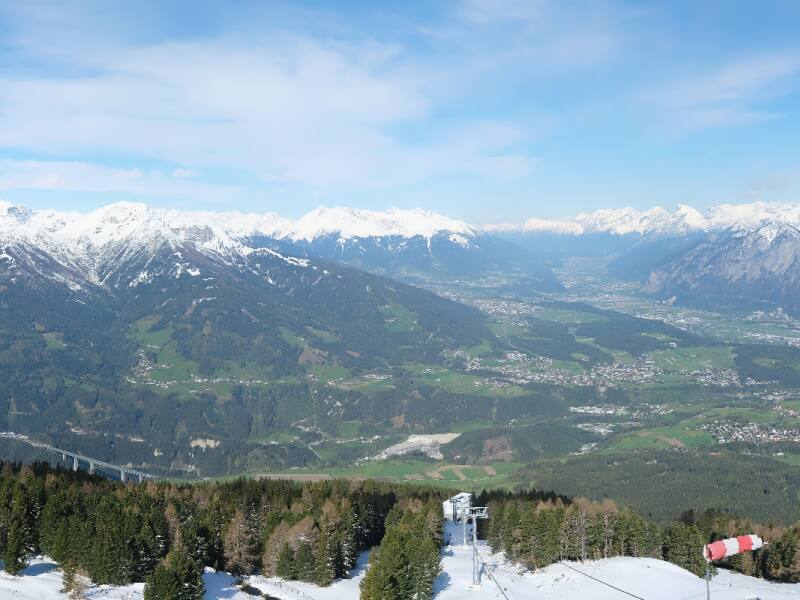
Alpine hiker's paradise Kofel
Just south of the Tyrolean capital, the Kofel rises up, the ideal panoramic mountain above Innsbruck. Here an incomparable, alpine nature paradise opens up to the hiker. All hikes are also suitable for children!
- Difference in altitude
- Ascent 220m / Descent 200m
- Walking time
- 2 hours
- Distance
- 5.7 kilometers
Starting point: Patscherkofel cable car mountain station. Continue along the summit trail to the first bend, where there is a turn-off to the right to the Jochleitensteig panoramic trail, which leads around the summit to the Almgasthof Boscheben and further along the Zirbenweg trail back to the Patscherkofel cable car mountain station. Also possible in the opposite direction.
- Difference in altitude
- Ascent 0m / Descent 950m
- Walking time
- 2.5 hours
Leisurely alpine hike. Take the Patscherkofel cable car to the top station. From the mountain station in the direction of the Hochmahdalm and on to the Patscher Alm along the forest path to Patsch.
- Walking time
- 5 hours
Around the Patscherkofel. Patscherkofel cable car mountain station, via the Zirbenweg trail towards Almgasthof Boscheben and on to Meissner Haus. Out of the valley, marked alpine path 1,600m from the south to the north side of the Patscherkofel. Heiligwasser Alpine Inn - Patscherkofel cable car valley station.
- Walking time
- 5 hours
From the Patscherkofel mountain station approx. 2.5 to 3 hours to the Glungezerhütte. Via the Zirbenweg trail first to the Almgasthof Boscheben, after another 20 minutes trail junction. The Glungezer-Höhenweg branches off to the right on the south side of the Viggartal valley and leads in about 1.5 hours past the Viggarspitze to the Glungezerhütte. Return along the same path (2 hours to the Patscherkofel) or descend to the Tulfein Alm (Glungezerbahn to Tulfes, post bus to Igls) or via the Zirbenweg back to the Patscherkofel.
- Difference in altitude
- Ascent 0m / Descent 950m
- Walking time
- 3 hours
From the Patscherkofel cable car mountain station east to the Lanser Alm and on to the Heilig Wasser Alpine Inn and the Patscherkofel cable car valley station.
- Walking time
- 3.5 hours
Easy mountain trail from alp to alp. Patscherkofel cable car mountain station - Lanser Alm - Sistranser Alm - Aldranser Alm - Rinner Alm - Alpengasthof Halsmarter or Tulfes.
- Difference in altitude
- Ascent 280m / Descent 280m
- Walking time
- 1.75 hours
- Distance
- 5.4 kilometers
The route leads from the Patscherkofel cable car mountain station on a wide hiking trail (suitable for prams) to the summit of the Patscherkofel. Height difference 280m. And back again. Refreshments are available at the Patscherkofel shelter and the "Das Kofel" restaurant at the Patscherkofel cable car mountain station.
- Walking time
- 24 days stages
Go where the eagle flies! The eagle is bold and the Eagle Trail has it all. In the high alpine mountain world, close under the sky, it runs from east to west through the whole of Tyrol. The course of the trail resembles the silhouette of an eagle soaring in the skies with its wings spread wide.
Alpine experience, sure-footedness and a head for heights are the prerequisites for many of the stages in order to be able to take on the challenge: 320 kilometres of hiking between Wilder Kaiser and Arlberg, 24 daily stages from easy to difficult, from gentle to jagged, from exhilarating to extremely strenuous. 23,000 vertical metres uphill, 20,000 vertical metres downhill.
The East Tyrolean Eagle's Path is shorter, but just as grandiose and demanding: nine stages between the Venediger and the Großglockner, 93 kilometres long, about 8,000 metres of altitude uphill and almost as many downhill. Countless steps, hundreds of summits, thousands of magnificent views!
The Patscherkofel is located on the Adlerweg on stage: 13.
You can find more information at: